
Get exploring with these geology resources. This blog post supplements this video from our Discovery Centre team which you can watch here.
Geological maps show the distribution of rocks on the surface of the Earth, and are a fantastic way to explore our planet from the comfort of your own home. To help you get started exploring, here’s a ‘toolbox’ of useful resources:
Maps

Macrostrat has geological maps of most of Earth’s land surface.
Rockd lets you access geological maps while out and about, and uses the GPS in your smartphone to tell you about nearby rock units. Free from the App Store and Google Play.
Reading the map
The colours on the map are different rock units, and clicking on any of them will bring up information about it. What rocks do you have in your backyard?
Remember that rocks are classified into three major categories: sedimentary (forming from sand, mud and gravel, mostly in rivers, lakes and the ocean), igneous (forming from the cooling of molten rock, commonly associated with volcanoes), and metamorphic rock (formed by the alteration of other rocks by extreme heat and pressure, commonly associated with movement of Earth’s crustal plates and the formation of mountain ranges).
You might also see some thick, black lines. These are faults, where the rocks have broken and shifted. They’re commonly associated with earthquakes, but most of the faults in Queensland aren’t currently active.
The coloured rock units and faults all overlap each other, because Earth’s surface is dynamic and constantly in motion. Mountain ranges are worn down by erosion, creating sediment that travels down streams and is deposited where it will eventually create sedimentary rocks. The slow movements of Earth’s crust create faults and volcanoes. Every landscape has a story.

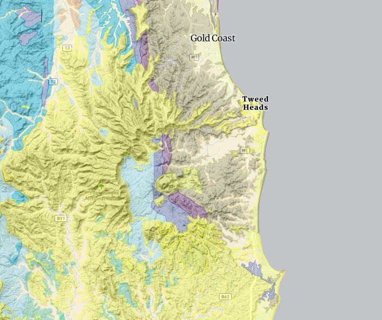
You can see one such story if you look at the Gold Coast and northern New South Wales on the map. You’ll see a large area of yellow rock that forms a ‘C’ shape, and includes the mountains of the Lamington Plateau and Border Ranges. These are igneous rocks, and they are the eroded flanks of a massive volcano. At the centre of the ‘C’ is Wollumbin (Mt Warning), which is the cooled magma chamber that was the heart of the volcano. This volcano erupted about 23 million years ago, and is estimated to have been two kilometres high at its peak. Erosion has since reduced it substantially, and uncovered underlying rocks that had been buried by lava.
Geological time

When exploring geological maps, you’ll most likely come across some names for intervals of geological time that aren’t familiar (Wuchiapingian, anyone?). The international chronostratigraphic chart is your guide to making sense of deep time. This chart is arranged from youngest at the top to oldest at the bottom, because that’s the way that rocks are stacked.
You can also explore deep time with the Geological Timescale: Australia through time app, free on the App Store.
Books
[image: photo of a cool fossil from the QM image library [shot of Lark Quarry footprints would be ideal, and there don’t seem to be any suitable images of this in the DAMS]. Caption something like “dinosaurs were here.”]
In search of ancient Queensland is an extensive exploration of the geological history and fossil record of the state. Highly recommended.
The ‘rocks and landscapes’ series has books focussed on the geology of Brisbane, the Sunshine Coast, the Gold Coast, the wet tropics, and National Parks of northern, central and southern Queensland. They’re valuable guides for learning about the rocks, and how the landscape has changed over time.
So, what rocks can you find in your area? What do they tell you about the distant past, and how our world has changed over time? Did you once have an ocean in your backyard? Or a volcano? Have fun exploring!
If you have an interesting rock or fossil that you want to know more about, or have a question about Queensland’s deep history, you’re welcome to contact the Queensland Museum Discovery Centre.

You must be logged in to post a comment.