
Written by Dr Geraldine Mate, Principal Curator, Industry, History and Technology.
It’s a nerdy boast, I know, but I love maps! Colourful touristy maps, contour maps, historic maps with wheat, sugar and gold country blithely shaded out, hand-drawn maps with names of people as important as names of places, and even the busy cadastral maps – dimensioned and officially (officiously?) denoting gazetted reserves, roadways, property boundaries and survey points. They all somehow convey a little bit about the landscape they depict. So what do maps have to do with archaeology?

Archaeology is about material culture – physical remnants of the past, and understanding how people once lived. But when you think about people in the past, you are invariably drawn to where they were, where they lived, as well as what they wore, ate, and used. And this is where it gets tricky for archaeologists. We can identify physically where people may have lived, or spent a moment even, but how can we understand what they thought of that place, how they saw it, and why it was where they chose to set down -either for a moment or a lifetime.

Cultural landscapes – landscapes of meaning and activity – present challenges in how we can understand the way past people regarded the landscapes and places they lived in. In historical archaeology, we have a number of lines of evidence to help try and understand people’s perceptions of these places. These include photographs, newspapers, official documents and private expressions of ideas in letters and diaries, and of course, maps. For an historical archaeologist, the wonderful feeling of locating these whispers from the past can be equal parts excitement and frustration. A diary that records in detail the day to day happenings in a small town can give the researcher a sense of intimacy and understanding of the people they are researching, but can also be frustrating when those tantalising glimpses fail to address the one person or place you are particularly interested in. And while sources such as photos, maps and newspaper articles can all be illuminating, they also come with inherent biases of the recorder or writer, impacted by the intent of the recording, the context of the day, or the position of the person making the record. So a ‘local correspondent’ writing to a newspaper may well be trying to promote his town or venture, an official recording a mine may have no interest in the people who live nearby, or a diary of a young female teacher may not reveal anything about the details of the agriculture or mining going on around her.

Having said this, in historical archaeology these same sources give us some insight into what people in the past thought was important and how they viewed them through the photos they took, the maps they drew, and the places they described.
I had an interesting discussion with an archaeological colleague recently that has set me to thinking about how people in the past saw their world. My colleague argued that there is no way we can truly understand the meaning people took from landscapes in the past.
Now this is a fairly academic argument that has specific schools of thought, supported by people with very different and deeply held views. (I hadn’t realised up until now I was one of them!). But is it really important? In the challenges of everyday life perhaps not, but as a part of understanding how people behaved in the past, and to judge which heritage places are important and why, I think it has some relevance. This brings us back to historical documents.
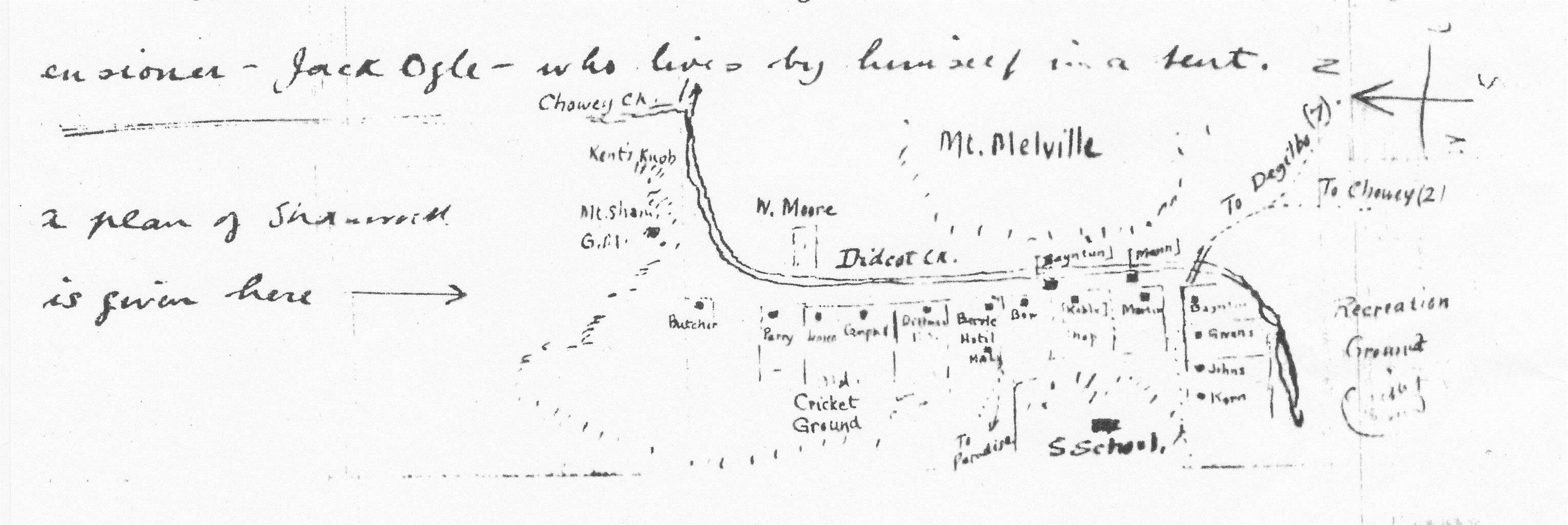
In historical archaeology we are fortunate to have these representations of landscapes from the past. We can see not only people but what they wanted recorded. We can see the emphasis they place on particular aspects of their everyday. We can find out the names given to places, names that may be otherwise lost in the depths of time, and understand which were the important places, by virtue of their being recorded. Particularly in hand drawn maps and personal diary writings we hear first-hand voices from the past that explain the events that took place or the way a particular place was regarded. These are all elements of the cultural meanings held in landscapes.

So maps for me do give the opportunity to understand a little of past landscapes, and how they are viewed. For Mount Shamrock, a 19th century gold-mining town outside of Biggenden in Queensland, we get a picture of a mining town where the mine was an important feature in the town, yet also a town where the relationships between the residents are important enough to transcribe onto a map and are features of the everyday social milieu. Government authorities saw it as “a mine of great promise” (Annual Report of the Department of Mines 1896) with the locals promoting a “settled and business like aspect” (Maryborough Chronicle 1887). Elsie Bilbrough, a young teacher recently arrived from England, saw wilderness, flooding and disorder. From maps, diaries and newspapers we are able to paint a picture of a 19th century town that acknowledges that different people experience in different ways.

These readings add to the interpretation of the physical archaeological remnants on the ground so that the stumps of the school echo with the voices of teachers and children and the kerbing up the main street can be imagined resounding to the boots of the Mining Warden and investors in the mine.
Join us as we celebrate National Archaeology Week with our special daily lunch time Meet our Curator sessions in the Discover Centre.
Meet Geraldine today for her talk ‘Mapping the Past’ at 1pm – 2pm.
Find out more on our website.


You must be logged in to post a comment.